
Install the app
How to install the app on iOS
Follow along with the video below to see how to install our site as a web app on your home screen.
Note: This feature may not be available in some browsers.
You are using an out of date browser. It may not display this or other websites correctly.
You should upgrade or use an alternative browser.
You should upgrade or use an alternative browser.
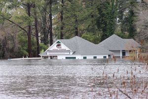
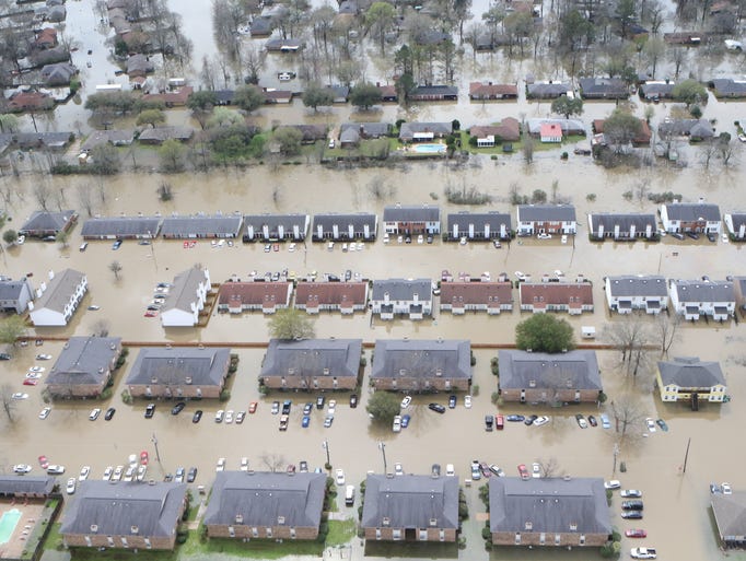
Recent Flooding in Louisiana.
- Thread starter JAG89
- Start date
JAG89
THE NEW AMERICA'S TEAM
IMO, I think Shreveport, LA is now a flood prone area since there is no river control structures (lock and dam) north of it. The nearest lock and dam to Shreveport, LA is 15 miles south of the city. IMO, water reaches that control structure and backs up.
Here's a video that shows high waters along the Red River 10 miles south of Shreveport, LA before the flooding from the recent storm.
Here's a video that shows high waters along the Red River 10 miles south of Shreveport, LA before the flooding from the recent storm.
The Founder
Well-Known Member
This is a re-assessment year for property also...meaning if a property is flooded the taxes will be prorated for the amount of time that the structure is not usable. Meaning less tax money. We have a meeting next week to decide what the affected parishes will do.
In_The_662
Deeeeep In The Delta.....
I live right across the street from a river. At its highest it usually can come within 30 feet of the street. Right now it's probably 15-20 feet (before this evening's showers which lasted about 2 hours). Most of the streets are under water because there is no where for the pumps to pump the water. It's supposed to storm tomorrow before finally drying out for a couple of days Monday and Tuesday so here's to praying that we don't get at least 3-4 inches tomorrow.
Greenville has probably been hit the hardest here (since the Mississippi River is flooding as well that causes Greenville to get flooded out)
Greenville has probably been hit the hardest here (since the Mississippi River is flooding as well that causes Greenville to get flooded out)
JAG89
THE NEW AMERICA'S TEAM
A 5-mile long flight of Cenla Helicopter in Natchitoches Parish showing LA Hwy.1 flooded the entire length.
Cenla Helicopter flying along I-49 in Natchitoches Parish. LaDOTD will be doing a lot of embankment repair due to the erosion along I-49 once the waters recede.
Cenla Helicopter flying along I-49 in Natchitoches Parish. LaDOTD will be doing a lot of embankment repair due to the erosion along I-49 once the waters recede.
JAG89
THE NEW AMERICA'S TEAM
It's crazy how my hometown (Alexandria, LA) were able to escape most of the flooding, but almost every parish (Vernon, Grant, Natchitoches) around it had massive flooding. IMO, Shreveport, LA is now flood-prone due to the only control structure (lock and dam) on the Red River is 15 miles south of the city. There is no river control structure north of the city. Therefore, there is nothing to slow down the waters from the Red River through Shreveport, LA. IMO, the U.S. Army Corps of Engineers needs to find some means of protecting Shreveport from the rising waters of the Red River.
buckwheat1911
Well-Known Member
Why wasn't the water able to drain in some of these areas? When I was at Grambling, I can't ever recall having an issue with flooding in Grambling, Monroe, Shreveport and surrounding areas. It was usually south Louisiana that would have flooding.The Monroe Area was hit hard as well.
.
Businesses around the Pecanland Mall area:

JAG89
THE NEW AMERICA'S TEAM
Why wasn't the water able to drain in some of these areas? When I was at Grambling, I can't ever recall having an issue with flooding in Grambling, Monroe, Shreveport and surrounding areas. It was usually south Louisiana that would have flooding.
The intensity of rainfall was of record proportion and I'm sure parts of North Louisiana didn't take the precautionary measures to prepare, such as the maintenance and cleaning of its storm drain system. Parts of South Louisiana flooded too, such as Covington, LA along the Pearl River. IMO, since the Red River has been made navigable with eleven different lock & dams from Avoyelles Parish to Caddo Parish, Shreveport is now flood prone, since the last lock & dam is 15 miles south of the city. Waters from the Red River rushes through Shreveport and starts to backup at the lock & dam 15 miles south of the city.
Flooding in St. Tammy Parish and parts of South Louisiana:
http://www.nola.com/weather/index.ssf/2016/03/president_obama_declares_major.html#incart_river_home
The Founder
Well-Known Member
When I was at Grambling, I can't ever recall having an issue with flooding in Grambling, Monroe, Shreveport and surrounding areas.
Umm it flooded. That's why the government built a new post office. Moreover, the surrounding areas flooded it's just that we didn't have social media to see it all.
Yet, the reason Adams and Woodson did not flood as often was because the state highway running through the campus was lower than the buildings. Therefore the drainage would force water back in to the ditches and trenches.
Well when the four-lane road was built there were new building standards for flood zones. So the leadership felt that drainage would not be a problem and did utilize adequate and updated products. Now the road is higher than the structures and the drainage system is outdated.
The only way to stop the flooding is to demolish the buildings and build new structures at height of the College of Business. If you notice driving to the president's home and the Elementary school it is on an incline.
This is the reason why I keep telling people that GSU needs NEW structures rather than renovations. Building new structures requires the design to take in to consideration of the flood zone and up to date drainage systems.
Yet, folks want to keep these old buildings.
If you notice the new dorms have not flooded and are in the same flood zone and incidentally are lower than the state highway. It's because under them is a state of the art drainage system. GSU does not own those dorms which is why they have their own maintenance crews and lawn service.
JAG89
THE NEW AMERICA'S TEAM
Umm it flooded. That's why the government built a new post office. Moreover, the surrounding areas flooded it's just that we didn't have social media to see it all.
Yet, the reason Adams and Woodson did not flood as often was because the state highway running through the campus was lower than the buildings. Therefore the drainage would force water back in to the ditches and trenches.
Well when the four-lane road was built there were new building standards for flood zones. So the leadership felt that drainage would not be a problem and did utilize adequate and updated products. Now the road is higher than the structures and the drainage system is outdated.
The only way to stop the flooding is to demolish the buildings and build new structures at height of the College of Business. If you notice driving to the president's home and the Elementary school it is on an incline.
This is the reason why I keep telling people that GSU needs NEW structures rather than renovations. Building new structures requires the design to take in to consideration of the flood zone and up to date drainage systems.
Yet, folks want to keep these old buildings.
If you notice the new dorms have not flooded and are in the same flood zone and incidentally are lower than the state highway. It's because under them is a state of the art drainage system. GSU does not own those dorms which is why they have their own maintenance crews and lawn service.
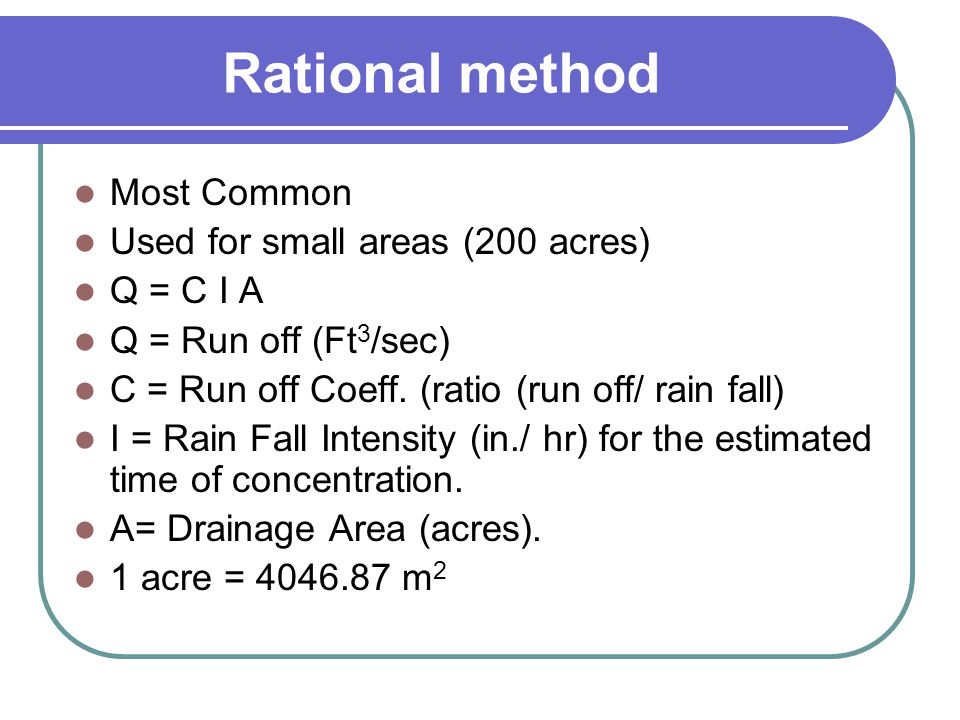
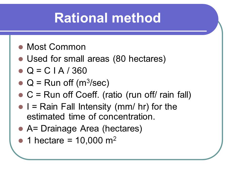
It sounds like Grambling needs a storm drainage study. Building new buildings might not be the most feasible or best option. If a building is below elevation, sump pumps can be installed to pump the water out, but that would require more maintenance and upkeep for the system. GSU should hire an engineering firm to study its drainage. Drainage studies are not an exact science, which is shown in the Rational Method of Q=CIA.
For cubic feet per second discharge:
For cubic meter per second discharge:
Last edited:
JAG89
THE NEW AMERICA'S TEAM
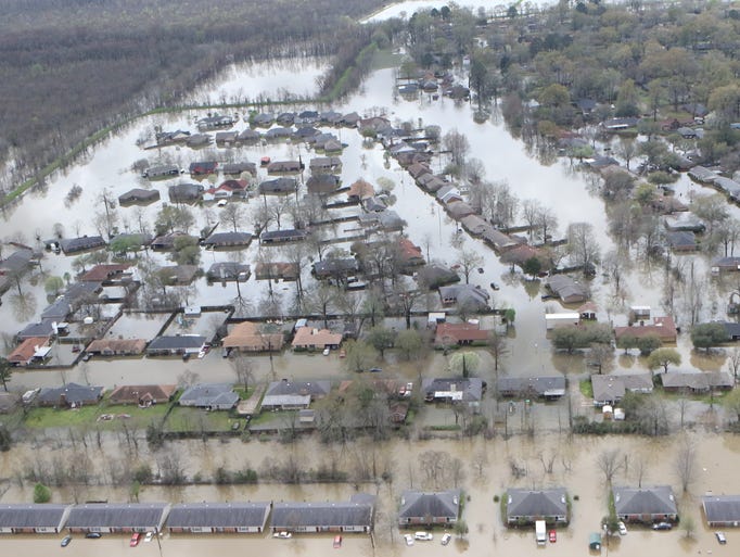
Homes flooded in Monroe:
http://www.thenewsstar.com/picture-...the-flooding-in-northeast-louisiana/81692124/
http://www.thenewsstar.com/picture-...the-flooding-in-northeast-louisiana/81692124/

The Founder
Well-Known Member
It sounds like Grambling needs a storm drainage study. Building new buildings might not be the most feasible or best option. If a building is below elevation, sump pumps can be installed to pump the water out, but that would require more maintenance and upkeep for the system. GSU should hire an engineering firm to study its drainage. Drainage studies are not an exact science, which is shown in the Rational Method of Q=CIA.
For cubic feet per second discharge:
For cubic meter per second discharge:
Brother you are speaking to the choir. Hiring an engineering firm is not the problem....paying them is. Furthermore, the leadership at GSU is quite frankly not the most intelligent people as far "outside the classroom knowledge" is concerned.
The Founder
Well-Known Member
Homes flooded in Monroe:
http://www.thenewsstar.com/picture-...the-flooding-in-northeast-louisiana/81692124/
The flooding on 425 is the highway I use to go to my farm in Oak Ridge when I go through Bastrop and Mer Rouge.
Keno1970
Shrewd1
Natchitoches is my hometown. I spoke with my uncle Saturday and he said he's never seen it like this! He has lived there all his life, almost 70 years...The Natchitoches area was hit really hard.
The main road (LA Hwy 6) leading into Natchitoches, LA from I-49 near Northwestern State University campus.
LA Hwy 1 south of Natchitoches, LA.
Lake Sibley near Northwestern State University:
JAG89
THE NEW AMERICA'S TEAM
Natchitoches is my hometown. I spoke with my uncle Saturday and he said he's never seen it like this! He has lived there all his life, almost 70 years...
Cenla Helicopters have done plenty of flyovers in Natchitoches Parish. They routinely fly along the Red River checking the water levels at different points. Here's a link to their FB page: https://www.facebook.com/Cenla-Helicopters-342795352409433/?fref=ts
Here's a flyover from today along Cane River Lake in Melrose, LA.
JAG89
THE NEW AMERICA'S TEAM
Brother you are speaking to the choir. Hiring an engineering firm is not the problem....paying them is. Furthermore, the leadership at GSU is quite frankly not the most intelligent people as far "outside the classroom knowledge" is concerned.
I think it has more to do with the school's priorities. Now that Governor Edwards is the governor of Louisiana and he seems to be moving the state in the right direction, GSU needs to put together a wish list of things once the funds do come available through the state. Governor Edwards definitely has pledged to increase funding for higher education in Louisiana. Also, GSU might want to consider adding storm water detention or retention ponds when it builds a new facility or a new road, which are ponds that receive any additional runoff from new development in order to keep the existing drainage system from being inundated, but engineering would be required to calculate the size (volume) and depth of the pond. I believe Prairie View has recently added a pond on its campus. Not only ponds are aesthetically pleasing, but they also provide a means of collecting and storing excessive runoff during big storm events. Southern has a natural pond in Lake Kerman. It is behind the Student Union and drains to the Ravine on campus.
Last edited:
The Founder
Well-Known Member
Also, GSU might want to consider adding storm water detention or retention ponds when it builds a new facility or a new road, which are ponds that receive any additional runoff from new development in order to keep the existing drainage system from being inundated, but engineering would be required to calculate the size (volume) and depth of the pond. I believe Prairie View has recently added a pond on its campus. Not only ponds are aesthetically pleasing, but they also provide a means of collecting and storing excessive runoff during big storm events. Southern has a natural pond in Lake Kerman. It is behind the Student Union and drains to the Ravine on campus.
If you examine a satellite view of GSU and surrounding areas you would see there are enough areas to do....the problem is GSU leadership. When you have folks with PhDs and EdDs thinking they are smart when they have no common sense.
JAG89
THE NEW AMERICA'S TEAM
If you examine a satellite view of GSU and surrounding areas you would see there are enough areas to do....the problem is GSU leadership. When you have folks with PhDs and EdDs thinking they are smart when they have no common sense.
I know there is enough land to do that. I used to work for an engineering firm that did work for GSU. Like I previously stated, GSU needs to prioritize its needs from its wants and hire the right people to do the work. Sometimes when we (Black people) get our PhDs and EdDs we try to re-invent the wheel, which doesn't make any sense.